Living in coastal counties, Mobile and Baldwin citizens are familiar with the threat of flooding. Whether by a hurricane or a very rainy day, many residents are faced with the possibility of finding their streets, sidewalks, and potentially their front stoops, underwater.
Understanding the real risk of flooding is critical in striving for a more resilient Gulf Coast. To aid in the discussion about coastal flood risks, the National Oceanic and Atmospheric Administration (NOAA) Office for Coastal Management has recently developed the Coastal Flood Exposure Mapper. This tool “supports users undertaking a community-based approach to assessing coastal hazard risks and vulnerabilities by providing maps that show people, places and natural resources exposed to coastal flooding” (NOAA). Though it is not the absolute determinate for risk in our region, it is useful in combination with other resources to help guide the conversation about flood hazards in our community.
The tool allows a diverse array of users, including local community officials, to specifically select their location and explore maps without the need for formal training. As it was built with the public in mind, the tool is simple to use, navigate and share. The maps not only include layers on flood hazards, but also societal, infrastructure and ecosystem overlays.
Beyond the maps themselves, the online tool provides tips on how to use the maps in your community. These tips include who to include in the conversation, how to engage stakeholders and example discussion questions. The tool also instructs users how to either print or download community-specific maps to organizational websites.
As flood risk continues to be a pivotal topic for our community, valuable tools, including the Coastal Flood Exposure Mapper, can be used to help start and guide the conversations about risk and resilience along our coast. For more information on this tool, please contact Marian Hanisko (NOAA) at marian.hanisko@noaa.gov.
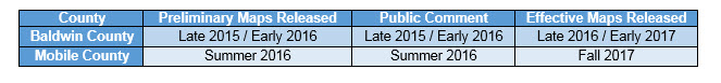
In addition to NOAA’s tool, the FEMA flood maps are also used to help determine risk in our area. The projected timeline for the development and release of the FEMA flood maps are as follows: